NOAA GOES Satellites – Applications and Use Cases in Space Science and Weather Monitoring
NOAA’s Geostationary Operational Environmental Satellites (GOES) are a critical component of modern environmental monitoring, weather forecasting, and space weather observation. Orbiting at around 22,000 miles above Earth’s surface in geostationary orbit, these satellites provide continuous, real-time data that is essential for a range of applications. From predicting hurricanes to monitoring solar activity, GOES satellites are indispensable tools in the scientific and weather prediction communities. In this blog post, we will explore the various use cases of NOAA GOES satellites and their profound impact on our daily lives, environmental health, and technology.
What Are NOAA GOES Satellites?

NOAA GOES satellites are a series of weather satellites launched and operated by the National Oceanic and Atmospheric Administration (NOAA). Positioned in geostationary orbit, they provide continuous, real-time monitoring of Earth’s weather, environmental conditions, and space weather. Unlike polar orbiting satellites, which move around the Earth at different latitudes, GOES satellites remain fixed over one region, offering consistent observation of the same area.
These satellites are equipped with advanced instruments capable of capturing high-resolution images of cloud cover, measuring atmospheric temperature and pressure, and detecting solar activity that can impact communication systems. GOES satellites are integral to modern weather prediction, environmental monitoring, and space weather forecasting.
Key Features of NOAA GOES Satellites
Geostationary Orbit: Positioned at 22,000 miles above Earth, GOES satellites remain in a fixed position relative to the planet’s surface, ensuring continuous observation of the same geographic area.
Advanced Imaging: Equipped with high-resolution imaging instruments, GOES satellites capture both visible and infrared images of Earth’s surface and atmosphere.
Real-Time Data Transmission: GOES satellites transmit real-time data back to Earth, providing essential information for weather forecasts and emergency response efforts.
Space Weather Observation: GOES satellites monitor solar activity, including solar flares and geomagnetic storms, which can affect Earth’s atmosphere and technology.
Primary Use Cases for NOAA GOES Satellites
1. Weather Forecasting and Storm Monitoring
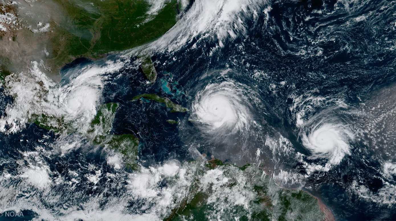
Image from GOES-16 shows Hurricane Katia (l) Hurricane Irma (m) and Hurricane Jose (r) in the Atlantic Ocean on September 7, 2017.
One of the primary uses of NOAA GOES satellites is weather forecasting. By continuously monitoring cloud cover, atmospheric pressure, and temperature, GOES satellites provide critical data that meteorologists use to predict short-term and long-term weather conditions.
Key applications in weather forecasting include:
Hurricane Tracking: GOES satellites track the formation, movement, and intensity of tropical storms and hurricanes. This real-time data allows meteorologists to issue early warnings, giving communities time to prepare for extreme weather events.
Example: The GOES-16 satellite provided continuous monitoring of Hurricane Irma in 2017, offering vital data that helped forecasters predict the storm’s path and intensity.
Severe Weather Alerts: GOES satellites assist in identifying thunderstorms, tornadoes, and severe wind patterns, providing early warnings to mitigate the effects of dangerous weather events.
Example: In 2019, GOES-17 observed intense thunderstorms in the U.S. Midwest, helping to issue timely warnings for flash flooding and tornadoes.
Cloud Formation and Movement: GOES satellites use infrared and visible imaging to monitor cloud formation and movement, which is crucial for forecasting weather changes such as rain, snow, and temperature fluctuations.
2. Environmental Monitoring

An image of California's Park Fire and smoke taken from space by NOAA's GOES-18 satellite on July 26, 2024. (Image credit: NOAA Satellites)
Beyond weather forecasting, GOES satellites are key players in monitoring environmental conditions across the planet. These satellites track various environmental phenomena, including ocean currents, wildfires, air pollution, and deforestation. By providing near-real-time data, GOES satellites help scientists and policymakers make informed decisions about managing natural resources and mitigating environmental threats.
Key applications in environmental monitoring include:
Wildfire Detection: GOES satellites are equipped with sensors that detect heat signatures from wildfires. This allows for rapid identification of fire outbreaks, helping to deploy emergency services and provide evacuation notices.
Example: In 2020, GOES-17 detected wildfires in California and Oregon, providing early alerts that assisted firefighting efforts.
Air Quality Monitoring: GOES satellites can measure atmospheric pollutants, including ozone levels and particulate matter, contributing to air quality assessments and environmental health research.
Example: Data from GOES-16 helps monitor particulate pollution in urban areas, aiding in efforts to improve air quality and public health.
Deforestation and Land Use Changes: By observing large-scale changes in vegetation and land cover, GOES satellites assist in tracking deforestation, urbanization, and changes in agricultural practices.
Example: Monitoring large swaths of tropical forests in South America has been facilitated by GOES-13, which tracks changes in forest cover over time.
3. Space Weather Observation
Space weather refers to the study of solar activity and its impact on Earth’s magnetosphere, atmosphere, and technology. NOAA GOES satellites play a critical role in monitoring solar flares, coronal mass ejections (CMEs), and geomagnetic storms, which can disrupt satellite communications, GPS systems, and power grids.
Key applications in space weather observation include:
Solar Flare Detection: GOES satellites continuously monitor the sun for solar flares—explosions on the sun's surface that can emit intense radiation and impact Earth’s atmosphere. By detecting solar flares in real-time, GOES satellites provide early warnings to protect communication systems and satellites in orbit.
Example: GOES-15 detected a significant solar flare in 2012, giving scientists a chance to prepare for its potential impact on Earth’s communication systems.
Geomagnetic Storms: GOES satellites track the impact of solar activity on Earth's magnetic field. These geomagnetic storms can cause disruptions in satellite operations, GPS systems, and power grids. The data helps mitigate the effects of these storms.
Example: In 2017, GOES-16 monitored a series of solar storms that impacted GPS signals and high-frequency radio communications, helping forecasters issue alerts to mitigate disruptions.
Cosmic Radiation Monitoring: GOES satellites are equipped with instruments to detect cosmic rays—high-energy particles from outer space—that can impact satellite systems and astronauts in space.
4. Climate Change Monitoring
NOAA GOES satellites also contribute to climate studies by continuously monitoring Earth’s climate systems. By observing long-term trends in temperature, cloud cover, and atmospheric composition, GOES satellites help researchers study global warming, sea-level rise, and other indicators of climate change.
Key applications in climate change monitoring include:
Global Temperature Measurements: GOES satellites provide real-time data on Earth’s surface temperature and atmospheric conditions, contributing to climate change models and predictions.
Example: Data from GOES-16 has been used in research on the melting of Arctic ice and changes in global sea levels due to warming.
Tracking Extreme Weather Events: The satellites monitor increased frequency and intensity of storms, heatwaves, and heavy rainfall that are associated with climate change, helping to understand patterns in climate disruption.
5. Disaster Response and Management
When natural disasters strike, NOAA GOES satellites are invaluable in assessing damage, coordinating emergency responses, and providing real-time data to support disaster relief efforts.
Key applications in disaster response include:
Hurricane and Flood Monitoring: GOES satellites track hurricanes and floods in real-time, helping emergency services understand the scale of the disaster and where to deploy resources.
Example: GOES-16 provided continuous monitoring of Hurricane Maria in 2017, assisting in evacuation plans and relief efforts.
Earthquake Aftershock Monitoring: Although GOES satellites can’t detect earthquakes themselves, they help monitor aftershock activity, coastal flooding, and changes in atmospheric pressure that follow a major seismic event.
NOAA GOES satellites are crucial tools in the global observation of weather, space weather, and environmental conditions. From weather forecasting to space weather monitoring and climate change research, these satellites provide real-time, high-resolution data that impacts the lives of millions. By supporting efforts in disaster management, environmental protection, and space science, GOES satellites are indispensable to modern society and scientific research.
Whether tracking hurricanes, detecting wildfires, or monitoring solar activity, NOAA GOES satellites play a central role in ensuring that we can predict, understand, and mitigate the effects of natural and space weather phenomena. As technology and science continue to advance, these satellites will remain vital tools in our efforts to protect the planet and its inhabitants.
How NOAA GOES Satellites Tie Into the Space Kitz Signal Hunters Kit
At Space Kitz, we aim to make space exploration accessible and engaging for students by providing hands-on learning experiences that connect them directly with the technology used to observe our planet. The Signal Hunters Kit is a perfect example of how NOAA GOES satellites are brought into the classroom.
By leveraging satellite technology, the Signal Hunters Kit allows students to receive real-time data from NOAA GOES satellites, offering a direct, interactive way to engage with space science and environmental monitoring. Here’s how the kit ties into the broader use cases of NOAA GOES satellites:
1. Real-Time Satellite Data Access
The Signal Hunters Kit allows students to connect directly with NOAA GOES satellites, providing them with live data feeds that mirror the very same information meteorologists and researchers use. Whether it’s tracking weather patterns, monitoring space weather, or observing cloud cover, students gain an understanding of how satellite technology plays a critical role in our daily lives. By receiving and analyzing data from these satellites, students explore the core of weather forecasting, space weather, and environmental science firsthand.
2. Hands-On Learning with Weather and Space Science
By utilizing the Signal Hunters Kit, students can study a range of weather systems in real-time, from monitoring the formation of hurricanes to analyzing cloud movements. The kit connects directly with GOES satellites that provide data on cloud formations, temperature variations, and atmospheric conditions—all crucial elements in understanding the weather forecasting process. Students will see how space-based observation helps in predicting and mitigating the impacts of extreme weather events.
References:
NOAA National Weather Service: https://www.weather.gov/
NOAA GOES Overview: https://www.noaa.gov/education/resource-collections/weather-atmosphere/goes
NASA Earth Science: https://earthobservatory.nasa.gov/
Space Weather Prediction Center (NOAA): https://www.swpc.noaa.gov/