How the Signal Hunters Kit Works and What Are NOAA GOES Satellites?
At Space Kitz, we are committed to bringing hands-on space exploration into the classroom. Our flagship product, the Signal Hunters Kit, allows STEM educators to engage students with satellite technology by directly receiving live data from NOAA’s Geostationary Operational Environmental Satellites (GOES). In this blog post, we’ll dive into how the Signal Hunters Kit functions and explore what makes NOAA GOES satellites an essential resource for space science education.
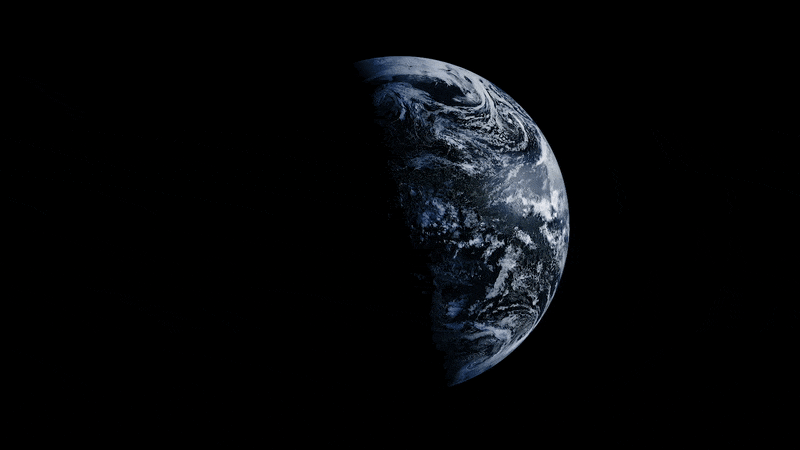
Imagery Captured with Signal Hunters Kit
How the Signal Hunters Kit Works
The Signal Hunters Kit is an innovative, interactive tool designed specifically for STEM classrooms to track and receive real-time satellite data from NOAA GOES satellites. Here’s a breakdown of how the system works to bring space science to life in the classroom:
1. Antenna and Base Station Setup
Antenna: The kit includes a high-performance antenna that captures satellite signals. This antenna is designed to be both durable and portable, allowing for easy setup and optimal reception of satellite data.
Base Station: The base station is the core of the system, where all the data is received and processed. This device connects to the antenna and uses specialized software to receive data from NOAA’s GOES satellites.


2. Tracking and Receiving Satellite Signals
The NOAA GOES satellites transmit data over a specific frequency, which the Signal Hunters Kit is tuned to receive. Once set up, students can track the movement of these satellites in real-time using the base station.
Students can then receive satellite signals from GOES, which provide crucial data on weather patterns, environmental conditions, and space weather.
3. Downloading and Analyzing the Data
Once the data is received, students can download satellite imagery and weather data for analysis. This includes images of cloud cover, temperature readings, and atmospheric conditions.
Students can interpret this data, making connections between satellite technology, weather forecasting, and real-time environmental monitoring.


4. No Internet Required
One of the most powerful features of the Signal Hunters Kit is that it operates independently of the internet. The kit works off the grid, relying solely on the antenna and base station to receive and process satellite data from GOES satellites.
This makes the kit an excellent choice for remote classrooms, rural schools, or any location where access to the internet is limited.
What Are NOAA GOES Satellites?
NOAA’s Geostationary Operational Environmental Satellites (GOES) are a fleet of advanced satellites used for weather forecasting, environmental monitoring, and space weather observations. These satellites orbit the Earth in a geostationary orbit, meaning they remain in a fixed position relative to a specific point on the Earth’s surface. This allows them to provide continuous, real-time data on atmospheric conditions, weather, and space weather phenomena.

Here’s why NOAA GOES satellites are essential for space science education:
1. Geostationary Orbit
GOES satellites orbit the Earth at about 22,000 miles above the surface, remaining fixed over one region. This enables them to continuously monitor weather and environmental changes without interruption.
By staying in the same position relative to Earth, GOES satellites provide valuable, real-time data on weather patterns, natural disasters, and space weather phenomena like solar flares and geomagnetic storms.
2. Weather and Environmental Monitoring
The primary function of NOAA GOES satellites is to monitor Earth’s weather and environmental conditions. Equipped with sophisticated sensors, these satellites provide high-resolution data on cloud cover, temperature, humidity, wind speed, and other atmospheric conditions.
GOES satellites are critical tools for weather forecasting, giving meteorologists up-to-date information to predict storms, hurricanes, and other extreme weather events.
3. Space Weather Observations
Space weather refers to phenomena such as solar flares, cosmic radiation, and geomagnetic storms that can affect Earth’s magnetic field, GPS systems, and communication networks.
GOES satellites are equipped with instruments to measure space weather, providing early warnings of potential disruptions caused by solar activity. This is crucial for protecting technology-dependent systems on Earth, such as satellites, power grids, and communication networks.
4. Real-Time Data Transmission
NOAA GOES satellites continuously transmit data in real-time, including high-resolution imagery of the Earth’s surface and atmospheric conditions. This data is vital for weather forecasting, climate studies, and disaster management.
The Signal Hunters Kit allows students to access this real-time data, providing them with a direct connection to space-based environmental monitoring and weather forecasting systems.
5. Applications of GOES Data
Weather Forecasting: GOES satellite data is used to monitor and predict weather patterns, from thunderstorms to hurricanes, and to issue early warnings to mitigate the effects of extreme weather events.
Disaster Response: During natural disasters, such as wildfires or hurricanes, GOES data is invaluable for tracking the progress of the event and directing relief efforts.
Climate Research: GOES satellites contribute to climate change research by continuously monitoring atmospheric conditions, sea surface temperatures, and other environmental factors.
Education: The Signal Hunters Kit allows students to access and interpret this satellite data, learning firsthand how satellites are used for environmental and weather monitoring.
Key Features of NOAA GOES Satellites
Advanced Imaging: GOES satellites capture both visible and infrared images of Earth, which are essential for weather monitoring and climate studies.
Continuous Observation: Unlike polar orbiting satellites, which pass over the Earth at various angles, GOES satellites provide continuous monitoring of the same region.
Multiple Instruments: GOES satellites are equipped with imaging and sounder instruments that provide data on cloud formation, atmospheric moisture, and other weather-related phenomena.
How the Signal Hunters Kit Leverages GOES Satellites for Education
The Signal Hunters Kit allows students to interact with real-time satellite data, creating an immersive educational experience. By connecting the kit to NOAA GOES satellites, students gain access to valuable data they can use to:
Track and analyze weather patterns using satellite imagery.
Study space weather and how solar activity impacts Earth-based technologies.
Understand the technology behind satellite communications and how satellites monitor environmental conditions.
Engage in hands-on learning by directly interacting with space-based monitoring systems, enhancing their understanding of satellite technology and space science.
The Signal Hunters Kit offers an exciting way for students to experience space technology and environmental science firsthand. By connecting with NOAA GOES satellites, the kit gives students access to real-time satellite data, allowing them to explore weather patterns, space weather phenomena, and the science behind satellite communications.
Whether you’re teaching about satellite technology, weather forecasting, or environmental monitoring, the Signal Hunters Kit offers a unique, hands-on way to engage students in space science. By bringing NOAA GOES satellites into the classroom, students can better understand the vital role these satellites play in our daily lives and the importance of space-based observation for weather prediction, disaster management, and climate research.
Unlock the wonders of space and weather science with the Signal Hunters Kit, and bring real satellite data into your classroom today!